[…] you have inevitably transitioned from one world to another, from a clear-cut context of physicists, mathematicians (and chemists) to a hazy and interdisciplinary environment. The challenge for environmental research lies in this need for cross-pollination…
Francesco Tampieri and Domenico Anfossi
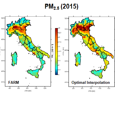
The project was funded by the Collaborative Research Call BRiC 2016-2018 with the aim of estimating, through technologies and methods for using large databases (“big data”), the health effects of air and noise pollution and meteo-climatic variables on the health of the Italian population. The project was structured into specific objectives focused on different spatial domains, from the entire national territory to the urban micro-scale. As part of this project, ARIANET contributed to the production of meteo-climatic and pollution maps for Italy for the years 2013-2015, at a spatial resolution of 5 km, and for six cities (Turin, Milan, Bologna, Rome, Bari, and Palermo) at a spatial resolution of 1 km. For a specific area of the City of Rome (12×12 km2) and for the year 2015, micro-scale modeling simulations were conducted at a spatial resolution of 4 m. The national and urban scale simulations were conducted using the prognostic meteorological model WRF and the atmospheric chemistry model FARM, while the micro-scale simulations were conducted using the PMSS modeling system.
The maps produced by the FARM model were then used, along with other spatial-temporal data such as population, land use, surface greenness, and road networks, as predictors in a Random Forest algorithm, a versatile machine learning method, to produce daily maps at higher resolutions, 1 km and 200 m, respectively for the national territory and the six cities.
This particularly innovative approach was made possible thanks to collaboration with researchers from the Department of Epidemiology of the Regional Health Service of Lazio (DEP-Lazio) and confirmed the value of cross-disciplinary insights and the necessity of a multidisciplinary approach to the issues of air pollution and its effects on health and ecosystems. The results of the activities carried out within the BEEP project have been the subject of numerous presentations at scientific conferences and publications in international scientific journals.