
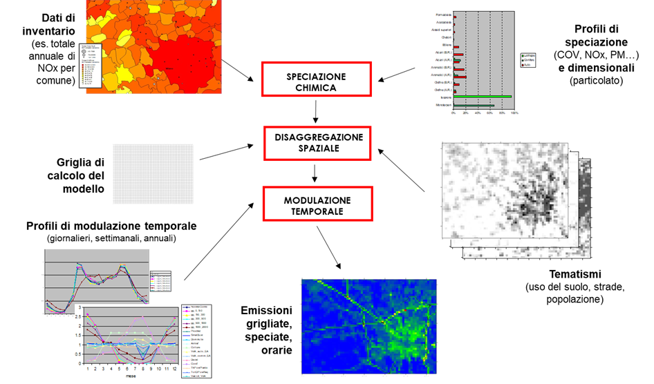
Based on the emission data for the domain in question, the emission input to the model is produced using the Emission Manager preprocessor, following this sequence of operations:
- Chemical Speciation: Chemical speciation involves converting aggregated species present in the inventory (total volatile organic compounds, total particulate matter, nitrogen oxides) into the chemical species required by the model (individual organic species or functional groups considered by the chemical mechanism, particulate matter divided into size classes and chemical components, NO and NO2) based on typical profiles for each emission activity.
- Spatial Disaggregation: Spatial disaggregation transforms the emission data originally associated with municipal polygons into the grid cells used by the model. This process is performed using thematic maps at the resolution of interest: each polygon is first intersected with the grid cells, and the associated emissions are allocated to the cells in proportion to the area of the intersections between the original polygon and the cells. This allocation is then adjusted using a grid-based thematic map correlated with the activity responsible for the emissions, which represents the percentage of each cell covered by a specific land use type (e.g., urban, industrial, agricultural areas, etc.).
- Temporal Modulation: Temporal modulation adjusts emissions to an hourly resolution, aligning with the temporal scale required by the model.
This sequence ensures that emission inputs are accurately represented in the model, taking into account chemical, spatial, and temporal variations.