
The #CyberItaly project, led by #ESA within the framework of the European Earth Observation space program #IRIDE, has the ambitious goal of creating a #DigitalTwin of the Italian territory. This digital twin will enable the analysis of hydrogeological risk, the state of urban greenery, and, of course, air quality.
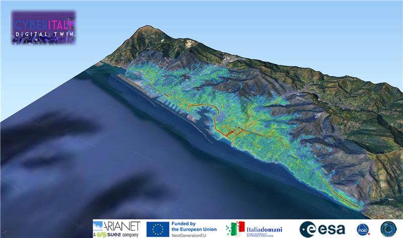
As part of the digital twin’s development, ARIANET provides pollutant dispersion modeling at both the local and microscale levels. In collaboration with #NAIS, the project’s first PoC tested the decomposition of local-scale concentration fields into #dispersion kernels to assess the impact of #traffic emissions on the city of #Genoa.
The system is designed to accurately reconstruct the atmospheric impact of specific emission scenarios, enabling annual-scale simulations at a local level within minutes. Thanks to its high computational efficiency, it quickly generates pollutant concentration maps, allowing for a detailed analysis of air quality evolution in urban environments over time and space.
At the heart of the system is the #Spray Lagrangian particle model, which calculates pollutant dispersion. This model is used to build a database of stationary and normalized dispersion simulations based on a classified set of meteorological conditions. The kernels in this database consist of precomputed ground-level concentration fields for each emission source, readily available for “what-if” scenario analyses with significantly reduced computation times.
A key element of the adopted computational approach is the convolution of dispersion kernels, enabling the generation of annual mean concentration maps at a local scale within minutes. The kernels are dynamically selected based on wind speed and atmospheric stability, in accordance with the underlying orography. The algorithm then rotates them to align with wind direction at each node of the meteorological grid and rescales them according to the specific emissions of each road segment. This approach allows for the rapid integration of emission variations into dispersion models, ensuring an accurate representation of atmospheric pollutant distribution.
A fundamental component of the tool is the intuitive #frontend developed by NAIS srl, which provides #DecisionMakers with a simple and effective interface for testing different emission scenarios. Users can adjust key parameters related to road pollution sources, such as vehicle fleet composition and the presence of restricted traffic zones. This makes it possible to assess, in real time, the effects of mitigation strategies—such as traffic reduction or the introduction of low-emission vehicles—on urban air quality.
In addition to annual concentration maps, the tool supports a forecast mode, providing a detailed prediction of atmospheric pollution at both the local scale and across the entire city. This information is crucial for urban planning and the development of effective environmental policies, enabling authorities to identify critical areas and evaluate the effectiveness of measures aimed at improving air quality.
Project Information
- Client: NAIS
- Completed Date: in progress